USA-Made · NDAA-Compliant Drones
Footage, partner announcements, and field deployments — pulled live from the Harris Aerial channels operators actually follow
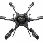
Mission footage, payload tests, and platform demos straight from the field
H4C Drone LiDAR Demo -- TopoDOT 2026
H6 Hybrid EFI Drone LiDAR Demo - TopoDOT Conference
Harris Aerial Drone LiDAR Demos - TopoDOT 2026
Carrier H6HL Drone + Hyspex VS-620 - Mining Application
Important: No API Key Entered.
Many features are not available without adding an API Key. Please go to the YouTube Feeds settings page to add an API key after following these instructions.
Press releases, partner announcements, and engineering milestones
Real platforms. Real missions. Real customers
Save the Date.
Join Harris Aerial on July 21 in Apopka, Florida for a day of live flight demonstrations featuring multiple UAS platforms, advanced payloads, and real-world mission applications.
Whether you’re involved in public safety, surveying, infrastructure, agriculture, or defense, you’ll have the opportunity to see our aircraft perform in realistic operating conditions and meet the team behind the technology.
Link in bio to register.
#HarrisAerial #DroneDemo #DroneTechnology #UAS #defense

One Day. Multiple Platforms.
See the Carrier HX8 Tether flying with the @nextvision.ltd NightHawk2-UZ EO/IR payload alongside the full Harris Aerial lineup at our HA Demo Day with @duncan_parnell
✔ Up to 24 hours of continuous tethered flight
✔ 21 lb payload capacity
✔ Room for additional mission equipment beyond EO/IR
Stop by, meet the team, and see why the HX8 tether is built for missions that demand endurance and flexibility.
Use link in bio to reserve your spot.
#Drone #NDAAcompliant #UAS #surveillance #Innovation
A great day in St. Augustine showcasing what happens when advanced UAV technology meets cutting-edge bathymetric mapping.
We had an incredible demo day with @duncan_parnell featuring the Harris Aerial H6 Electric equipped with the @yellowscan Bathymetric Navigator LiDAR system. It was a fantastic opportunity to demonstrate how the platform performs in real-world conditions while connecting with industry professionals and highlighting the capabilities of airborne hydrographic surveying.
The H6 Electric provided a stable, reliable flight platform throughout the demonstrations, and we’re excited with the quality of the dataset collected. Swipe to the end to see a glimpse of the results from the mission.
#Drone #innovation #engineering #LiDAR #aerial
Today we celebrate the spirit of innovation, resilience, and the people who make this country extraordinary. At Harris Aerial, we’re honored to build American-made UAS platforms that help support defense, public safety, and critical missions across the nation.
#drones #america250 #UAS #harrisaerial #americanmade
Join Harris Aerial on July 21st for an exclusive Demo Day featuring live flight demonstrations of the H6E and an exclusive first look at the all-new H4C platform ahead of its official release later this year.
Experience firsthand how Harris Aerial platforms integrate with advanced sensing technologies, including the new GeoCue TrueView 641 LiDAR, Sentera 6X Multispectral Sensor Array, and the Sentera 65R Global Shutter Sensor.
Discover how these integrated solutions are advancing surveying, infrastructure inspection, public safety, defense, and enterprise operations through live demonstrations and discussions with the Harris Aerial team.
Whether you’re evaluating your next UAS platform or simply want to see the latest technology in action, this is an event you won’t want to miss. More information regarding the H4C, GeoCue TrueView 641 LiDAR and the Sentera 6x Sensor Array is available in our bio.
@geocuegroup
@senterasensors
@duncan_parnell
#drone #lidar #uas #multispectral #survey
More time in the air. More data on the ground
Recently featured during U.S. Army Corps of Engineers training operations, the Harris Aerial H6 Hybrid demonstrated how high endurance UAS are transforming modern surveying and mapping.
Equipped with the GeoCue TrueView 660 LiDAR payload, the H6 Hybrid combines multi-hour flight capability with highly accurate terrain mapping, allowing teams to collect detailed data in environments where traditional aerial imagery falls short. With excellent vegetation penetration and reliable wire detection, the system helps capture the information they need while covering more ground in a single flight.
Link in bio to continue reading.
#LiDARmapping #drone #HybridDrone #NDAACompliant #UAS
🚨 Harris Aerial Officially Joins the Blue UAS Cleared List! 🚨
We’re proud to announce our official addition to the Blue UAS Cleared List. This validates our strict NDAA compliance, cybersecurity standards, and American manufacturing of heavy-lift hybrid and electric drones.
Built in Orlando, FL — ready for defense, public safety, utilities, forestry, surveying, and critical infrastructure missions.
Platforms Added:
Carrier H6 Hybrid EFI: https://harrisaerial.com/carrier-drones/carrier-h6-hybrid/
Carrier H6 Electric: https://harrisaerial.com/carrier-drones/carrier-h6-electric/
Carrier H6 Heavy-Lift: https://harrisaerial.com/carrier-drones/carrier-h6hl/
Official Blue List Link: https://bluelist.appsplatformportals.us/UAS-Cleared-List/
Let’s connect for demos and program support:
📩 info@harrisaerial.com
🌐 www.harrisaerial.com
#BlueUAS #HarrisAerial #NDAACompliant #AmericanMade #HeavyLiftDrones
Harris Aerial’s H6 EFI — our field-proven gas-electric hybrid drone — is already doing what no other US drone in its category can do.
Controlled by our advanced C-GCS ground control station, watch the H6 EFI Hybrid effortlessly carry the Phoenix LiDAR Systems RANGER-UAV22 FLEX — a high-performance 5kg LiDAR sensor no other platform in the H6 EFI’s class integrates and flies with this level of ease.
Gas-electric hybrid power • Extended endurance • Heavy-lift capability.
Designed, manufactured, and assembled in the USA.
#H6EFI #HarrisAerial #GasElectricHybrid #HybridDrone #DroneLiDAR #PhoenixLiDAR #RANGERUAV22 #RANGERUAV22FLEX #DroneLiDAR #LiDARMapping
From scope to delivery, every Harris Aerial system is mission-tuned in the USA — bring your payload, your radio stack, and your mission profile

