USA-Made · NDAA-Compliant Drones
A New Class of System: Three Laser Orientations, Three Cameras & Unlimited PP-RTX
GeoCue's fourth-generation RIEGL integration — the system for high point-density corridor mapping. The RIEGL VUX-120 runs three LiDAR scanners (nadir, +10° forward, -10° backward) with three oblique/nadir cameras for extremely detailed collection in one flight path. When scanning power lines, capture poles vertically, front and back. NDAA-compliant, with unlimited Trimble PP-RTX.
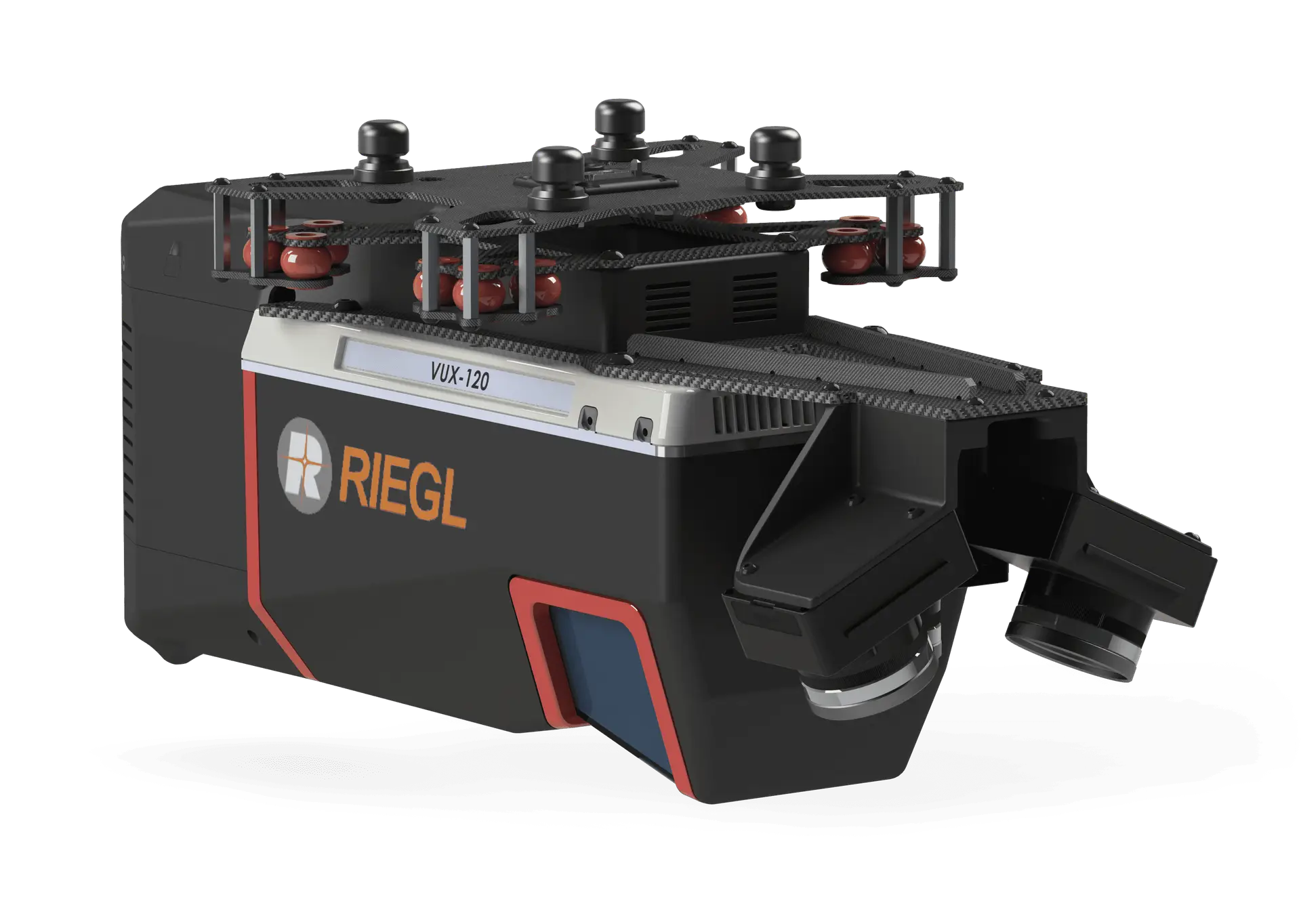
A corridor-mapping powerhouse built on the RIEGL VUX-120. Click the image to enlarge.
Three laser orientations, long range, and three cameras — the most detailed single-pass corridor data GeoCue produces.
The RIEGL VUX-120 fires nadir, +10° forward, and -10° backward — capturing power-line poles vertically, front and back, in a single flight path.
Up to 720 m usable range and a selectable 2.4 MHz pulse rate with up to 32 returns — extreme point density across long corridors.
Triple 1″ mechanical-shutter sensors with a hardware mid-exposure pulse deliver 60 MP combined RGB imagery, with custom camera configurations available.
All 720 payloads are NDAA-compliant and ship with unlimited Trimble PP-RTX — centimeter accuracy with no base station required.
| Data Collection | LiDAR + Imagery |
|---|---|
| LiDAR Scanner | RIEGL VUX-120 — 3 scanners (nadir, +10° forward, -10° backward) |
| Laser Returns | Up to 32 |
| Usable Range | 720 m for targets with > 20% reflectivity |
| Pulse Repetition Rate | Up to 2.4 MHz (selectable) |
| Scanner Precision | 5 mm |
| Scanner Accuracy | 10 mm |
| Camera Sensor | Triple 1″ mechanical shutter, hardware mid-exposure pulse, 60 MP combined RGB |
| Positioning & Orientation | Applanix APX-20 (other IMU options available) |
|---|---|
| GNSS/INS Position | 20–50 mm |
| GNSS/INS Angle | 0.015° Roll/Pitch, 0.035° Heading |
| Post-Processing | Unlimited Trimble PP-RTX (no base station) |
| System Precision | Typ. 10 mm; < 10 mm (1σ) at 80 m on concrete |
| System Accuracy | Typ. 3 cm RMSE; better than 5 cm 3D RMSE |
| Operating Temperature | -10°C to 40°C |
| Mass | 3.4 kg (payload unit only) |
Mass listed is the payload unit only and excludes accessories (battery, mount, antenna, power adapter). Scanner accuracy is stated at 1σ at 150 m range under RIEGL test conditions. A mandatory yearly maintenance fee is required from the second year.
Pair the TrueView 720 with the right Harris Aerial Carrier for your mission and operating environment.