GeoCue TrueView 540
A New Standard for Accuracy and Quality in the 500 Series
GeoCue and CHC Navigation bring the most efficient and flexible high-end LiDAR to North America with the TrueView 540. This next generation of the mid-range line offers enhanced density, improved accuracy and precision, and a superior point cloud — an engineering-grade sensor powered by LP360 at a mid-range price.
Engineering-Grade at a Mid-Range Price
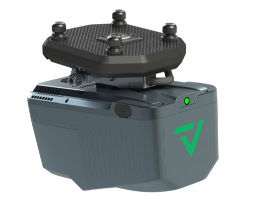
A high-end CHCNAV scanner, a 45 MP calibrated camera, and quick-connect TrueView integration. Click the image to enlarge.
High-End LiDAR, Made Accessible
Greater range, density, and precision than the rest of the 500 Series — with plug-and-play TrueView integration and the full LP360 software stack.
400 m Range, 500 kHz
A CHCNAV AA10 single-beam 1550 nm laser scanner with up to 8 returns reaches targets at 400 m for > 20% reflectivity — high density across large sites.
45 MP Calibrated Camera
A full-frame 45 MP global shutter camera with just 0.3 pixel of motion blur at 5 m/s, 80 m — crisp colorization and photogrammetry.
Engineering-Grade Accuracy
15 mm accuracy and 5 mm precision (1σ at 150 m), with typical 3 cm RMSE global accuracy for survey-ready deliverables.
Plug-and-Play TrueView
Quick-connect to drone and compatible with other TrueView payloads (such as the TV720 and TV535) for a flexible, swappable fleet.
Where the TrueView 540 Flies
Unveiling the Power & Performance Details
| Data Collection | LiDAR + Imagery |
|---|---|
| Laser Scanner | CHCNAV AA10 single beam, 1550 nm |
| Number of Lasers | 1 |
| Returns | Up to 8 |
| Usable Range | 400 m for targets with > 20% reflectivity |
| Total Pulse Rate | Up to 500 kHz |
| Rotation Speed | 50–250 scans/s |
| Beam Spot Size | 0.032° |
| Scanner Accuracy | 15 mm (1σ @ 150 m) |
| Scanner Precision | 5 mm (1σ @ 150 m) |
| Camera Sensor | 45 MP Global Shutter Full Frame; 81.2° × 59.5° FOV |
| INS | CHC and Honeywell |
|---|---|
| Post-Processing | Single Base (PPK) |
| PPK Performance | 0.02 m RMSE; 0.019° heading, 0.006° pitch & roll |
| System Precision | Typ. 20 mm; < 15 mm (1σ) at 75 m on concrete |
| Global Accuracy | Typ. 3 cm RMSE; better than 5 cm 3D RMSE |
| Control / Storage | WiFi; 512 GB × 2 |
| Power Consumption | 40 W |
| Operating Temperature | -20°C to 50°C |
| Dimensions | 212 × 125 × 185 mm |
| Mass | 1.9 kg (payload only); 2.15 kg with accessories |
What's Included
- TrueView 540 LiDAR Payload
- GNSS Antenna
- Sensor Hardcase
- Dual 512 GB onboard storage
- LP360 Drone Processing Software — includes Strip Adjustment, Photo & 3D Accuracy
- Optional LP360 Cloud Collaborate — Store & Share, Stream & View, Auto Ground Classification
- 1 year of hardware & software support
- 2 days of training — at GeoCue's Huntsville, AL office
Mass is 1.9 kg payload only; 2.15 kg with accessories. Scanner accuracy and precision are stated at 1σ at 150 m range.
Contact Us for a Free Quote Today
Pair the TrueView 540 with the right Harris Aerial Carrier for your mission and operating environment.